

Mapbiomas Indonesia Collection 2.0 is accessible to the public at no cost through the platform’s website. With Mapbiomas, we can see deforestation in detail. What happened before and after.
In the ever-evolving landscape of Indonesia, a country marked by its lush forests, sprawling agricultural land, peatlands, and plantations, understanding changes in land use is a complex, yet crucial endeavor. With a total land area of around 1,904,569 square kilometers, keeping track of rapid land transformations and the impacts of the climate crisis is no small feat.
RELEVANT SUSTAINABLE GOALS
Mapbiomas Indonesia Collection 2.0: A Leap Forward in Land Change Analysis
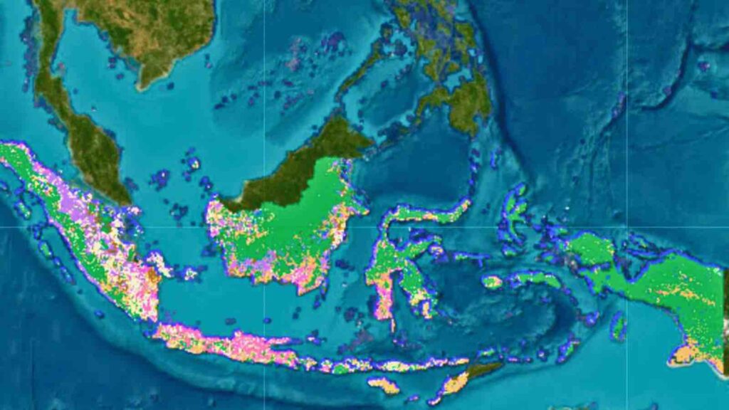
On October 23, 2023, in Bali, the launch of Mapbiomas Indonesia Collection 2.0 heralded a new chapter in land cover mapping. This updated platform boasts improved accuracy and completeness over its predecessor, offering insights into land cover changes from 2000 to 2022, with the significant inclusion of a new category: rice fields.
Previously capable of detecting natural forests, mangroves, and various other land types, the map now shows that forests encompass 56% of Indonesia’s territory. However, it also reveals a significant loss: over the past two decades, the nation has seen 9 million hectares of natural vegetation vanish, coinciding with a substantial expansion of oil palm plantations, which now cover an area of 10.52 million hectares.
Collection 2.0 has been meticulously refined, with accuracy testing conducted by ten experts and fourteen teams from Indonesian universities, achieving a 75% accuracy rate. In addition to land cover details, the map includes administrative boundaries from national to village levels, as well as spatial planning for forest and conservation areas, land-based commodity licenses, and social forestry.
Timer Manurung, Chair of the Auriga Nusantara Foundation and an initiator of Map Biomass Indonesia, noted the significance of this launch, stating, “This map will be an invaluable resource for a range of stakeholders, from government officials and academics to the general public.”
The map’s utility extends to environmental advocacy, as noted by Farwiza Farhan, founder of HAkA, a conservation-focused NGO in Aceh’s Leuser Region. She recounted a case from 13 years ago when a company illegally cleared land in a protected area, a violation initially overlooked by authorities due to pending permits. It was only through data from the Biomass Map that the government recognized the need for the company to restore the damaged forest.
Tasso Azevedo, the founder and coordinator of MapBbomas, emphasized the map’s role in monitoring land changes and enhancing environmental management decision-making. He highlighted how, in Brazil, Mapbiomas data has been instrumental in issuing valid warnings and reports since 2019.
Mapbiomas Indonesia Collection 2.0 is accessible to the public at no cost through the platform’s website. The platform is user-friendly, equipped with features for data analysis and export, making it an essential tool for those seeking to analyze and understand the intricate patterns of land use in Indonesia.
Lead image courtesy of Indonesia biomass map.
You may also be interested in :
Indonesia’s Deforestation Revolution: A Global Blueprint For Sustainable Forest Management