Deforestation, habitat encroachment, and poaching have decimated wild populations, driving the species closer to extinction; conservationists are turning to technology—using Google Earth’s satellite imagery and AI-driven tracking systems to safeguard the sun bears and better understand its habitat.
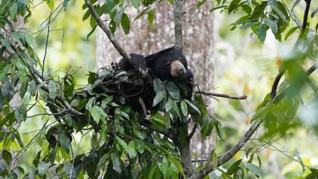
In the dense tropical rainforests of Southeast Asia, a unique and little-known species roams the treetops—the sun bear(Helarctos malayanus). Unlike its larger relatives in North America and Europe, this small, tree-climbing omnivore has evolved to thrive in the canopy, where it forages, naps, and avoids predators.
But despite its adaptability, the sun bear is in peril. Deforestation, habitat encroachment, and poaching have decimated wild populations, driving the species closer to extinction. Now, in an effort to safeguard the sun bear and better understand its habitat, conservationists are turning to technology—using Google Earth’s satellite imagery and AI-driven tracking systems to monitor populations and improve rescue efforts.
RELEVANT SUSTAINABLE GOALS
The Fight to Save Sun Bears
Leading this effort is Malaysian wildlife biologist Wong Siew Te, founder of the Bornean Sun Bear Conservation Centre (BSBCC) in Sabah, Malaysia. Wong’s dedication to these animals began decades ago when he discovered how little was known about them—even within the scientific community. More troubling, he found that many sun bears were being kept illegally in captivity, suffering from neglect and abuse in private zoos, crocodile farms, and even households that attempted to domesticate them as pets.
“It felt like a desperate situation, realizing how many sun bears were out there in terrible conditions,” Wong recalls. “They were misunderstood, mistreated, and largely forgotten.”
Determined to change this, Wong and his team at BSBCC focus on five pillars of conservation:
Rescue and Welfare – Confiscating illegally kept bears and providing them with proper care.
Rehabilitation – Reintroducing young bears into the wild when possible.
Education – Raising awareness about the species’ plight.
Research – Conducting scientific studies on bear behavior and habitat.
Ecotourism – Generating revenue to sustain conservation efforts.
Using Technology to Track a Secretive Species
The biggest challenge in sun bear conservation is simple: we don’t know how many there are in the wild. Unlike other bear species, which roam open landscapes and leave visible tracks, sun bears live in thick forests, making population estimates difficult.
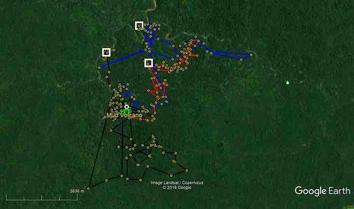
To tackle this, Wong and his team have turned to Google Earth Pro, using satellite imagery to map remote sun bear habitats and analyze how deforestation is impacting populations.
“These images give us a detailed view of the topography, the vegetation, and the land use,” Wong explains. “Some of these areas are so remote that detailed maps simply haven’t been available before.”
By overlaying Google Earth’s high-resolution imagery with data from:
Remote cameras (capturing photos of sun bears in the wild),
GPS tracking collars (monitoring their movement patterns),
On-ground observations from researchers,
…scientists can now pinpoint home ranges, migration corridors, and areas where sun bears are most vulnerable to human activity.
Data and observations about sun bears overlaid on Google Earth (Credit: Bornean Sun Bear Conservation Centre via Google Earth/ Medium)
Navigating the Jungle: Google Earth as a Field Guide
In a landscape where roads are scarce, rivers twist unpredictably, and thick foliage obscures everything, simply finding the right path is an enormous challenge.
Wong and his colleagues use Google Earth Mobile and GPS units to navigate through the jungle, often trekking deep beyond roads or traveling by boat with the help of local villagers.
“These maps help us find the best, safest, least-impactful routes,” Wong explains. “It makes a huge difference when we need to deploy camera traps or track a rehabilitated bear without disturbing other wildlife.”
While technology has greatly enhanced sun bear research, the most critical question remains unanswered: How many sun bears are left in the wild?
“We have a graduate student setting up a grid of remote cameras,” Wong says. “If we can capture enough data, we can finally start estimating population densities.”
This information is crucial—not just for saving sun bears, but for understanding the overall health of their ecosystems. As apex foragers, sun bears play an essential role in seed dispersal and forest regeneration. Their decline signals a deeper environmental crisis.
“As a biologist, I know how delicate ecosystems can be,” Wong emphasizes. “What happens to one species will likely affect many others. That’s why preserving sun bears is about more than just one animal—it’s about protecting the forests they call home.”
Sun bears are often called “the forgotten bears”—overshadowed in conservation efforts by pandas, polar bears, and grizzlies. But thanks to cutting-edge satellite technology, AI-powered research, and the dedication of conservationists like Wong, the world is finally starting to take notice.
With Google Earth mapping deforestation, GPS tracking monitoring movement, and AI-driven cameras counting populations, researchers are building a clearer picture of the challenges sun bears face—and how to protect them.
Lead image courtesy of Bornean Sun Bear Conservation Centre
An advertising copywriter and an avid novelist. Currently mastering the art of gardening. Her dream is to build her own permaculture farm for sustainable future in her hometown, Bandung, West Java Indonesia.