
At their most intense, the downpours that drove widespread flash flooding across Wellington early on Monday morning would have counted as extreme even by tropical standards.
But here in 2026, it is part of an increasingly familiar pattern reminding us that our communities and infrastructure aren’t yet prepared to cope with what a warmer, wilder future holds.
Over a 48-hour window, the capital saw rainfall totals that nearly tripled monthly averages, with some residents describing it as the worst flooding event since Wellington’s disastrous 1976 storm.
MetService reported that more than 70mm of rain fell in just one hour in parts of southern Wellington early on Monday morning. That is more than half the total rainfall typically recorded at the city’s Botanical Gardens over the whole of April.
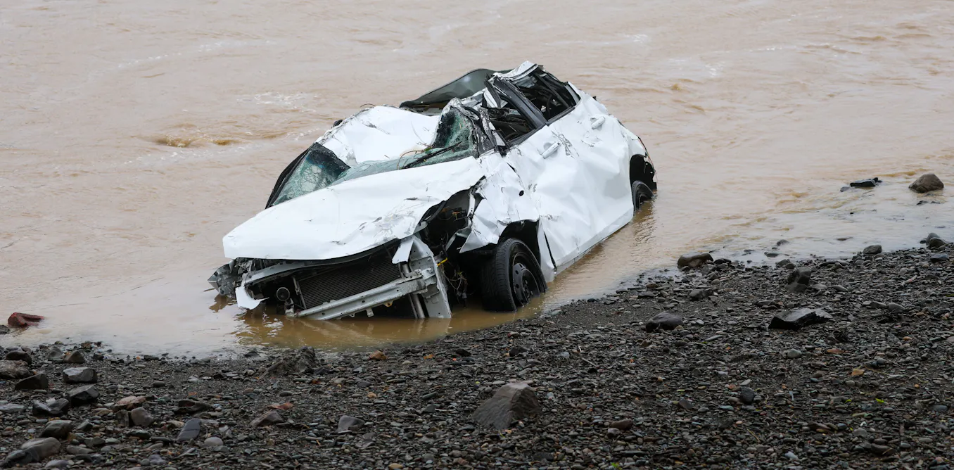
Impacts were immediate and severe. In some suburbs, entire streets were flooded. Vehicles were left floating in floodwaters; others were simply carried away.
Local emergency services were stretched, responding to more than 150 weather-related calls in a single morning, as hubs were set up in the suburb of Lower Hutt to support displaced residents.
Infrastructure across the region struggled to cope. Multiple sections of local state highways were forced closed by flooding and slips, with continuing disruption to Metlink transport services.
Wellington’s 1976 disaster cost tens of millions of dollars. The bill for this one is now being counted.
A tale of two storms
While the rainfall intensity may have felt distinctly tropical, the system behind this event was very different from Cyclone Vaianu a week earlier.
Vaianu began in the tropics, carrying warm, moisture-laden air south. This latest system, by contrast, developed out of the Southern Ocean. It was a large, slow-moving low-pressure system that drew cold air north as it moved over unusually warm seas in the Tasman.
Yet that contrast in origins matters less than it might seem.
Once a system has access to enough moisture and instability, the end result can be much the same: intense rainfall falling over a short period. In this case, cold air moving over warm seas helped generate widespread convection: clusters of thunderstorms producing heavy, localised downpours.
This helps explain why such a broad system could still produce highly uneven impacts. While forecasters were able to identify the risk of severe weather well in advance, pinpointing exactly where the heaviest rain would fall would have been extremely difficult.
That comes down to scale. Weather systems can be understood well across hundreds or thousands of kilometres.
But the most damaging rainfall often depends on processes playing out over just a few kilometres, or even less, where small variations in temperature, moisture and wind can determine whether one place is inundated while another escapes relatively lightly.
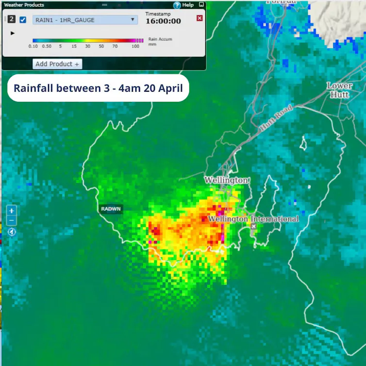
In Wellington’s case, such fine-scale dynamics made all the difference. Converging winds along the south coast helped drive moisture upwards and hold intense rainfall over the same areas for extended periods.
Storms such as this might not be unusual in themselves, as they occur often across the southern oceans. But when they strike highly populated areas, the impacts are amplified.
For the Wellington region, along with all those other areas of the country hit hard by this weather system over the weekend, timing also played a role.
Coming so soon after Cyclone Vaianu, the ground in many parts of the North Island was already saturated, increasing runoff and raising river levels. That meant this second system did not need to be as extreme in isolation to produce severe flooding.

More warming, bigger downpours
Whether or not a formal climate change attribution study is carried out, this event again reflects the i
Read More