
Nowhere in the Iberian Peninsula or the Balearic Islands has a tropical climate – for this to be the case, the average temperature in the coldest month would have to be 18°C or higher. The contrast between Spain’s winters and summers, and the low temperatures reached in winter, do not resemble those of any tropical climate.
However, over recent decades, climates across Mediterranean basin have begun to show signs of tropicalisation: the process of transitioning towards a tropical climate.
This is evident in several areas, including rising air and sea temperatures, shifting atmospheric patterns, and increasingly erratic rainfall.
Warmer air and seas
Firstly, a marked rise in air temperature – more pronounced than the global average – is making the Mediterranean’s winters shorter and its summers longer, bringing spring forward and delaying the onset of autumn. Some people believe that these transitional seasons have all but disappeared. They do still exist, but they have moved on the calendar.
Read more: Summers are getting longer each year, and it isn’t all fun and games
The temperature of shallow and deep Mediterranean water – down to a depth of around 100m – has also risen markedly.
These are clear, statistically significant trends. Water temperatures to the south of Mallorca exceeded 30°C on some days in recent summers. This is similar to, or even higher than, those found in the Caribbean and the Gulf of Mexico.

Shifting pressure systems
The Northern Hemisphere’s major wind belts and pressure systems, and the belt of tropical and subtropical high-pressure systems to the south of the Mediterranean basin – which cause the existence of the Sahara and other deserts at a similar latitude – all appear to be moving northwards.
This is because of the expansion of the Hadley cell, a global-scale tropical atmospheric circulation that governs weather patterns at equatorial and tropical latitudes.
If this trend becomes established, it will increase atmospheric stability in the Mediterranean region. Rainfall would become less regular in the region, with long dry spells punctuated by heavy downpours.
Mediterranean hurricanes
Warm waters are one of the necessary ingredients for a hurricane to form and grow. Rising sea temperatures will therefore expand the areas of the ocean where such a phenomenon can potentially form.
For a hurricane to form, the minimum surface temperature – down to a depth of several tens of metres – has to be around 26.5°C, a figure exceeded in large areas of the Mediterranean this summer. The abundant water vapour and the latent heat it carries provide the fuel for intense convective processes that generate storms, often resulting in torrential downpours.
Read more: The Mediterranean sea is capable of generating hurricanes and climate change will make them worse
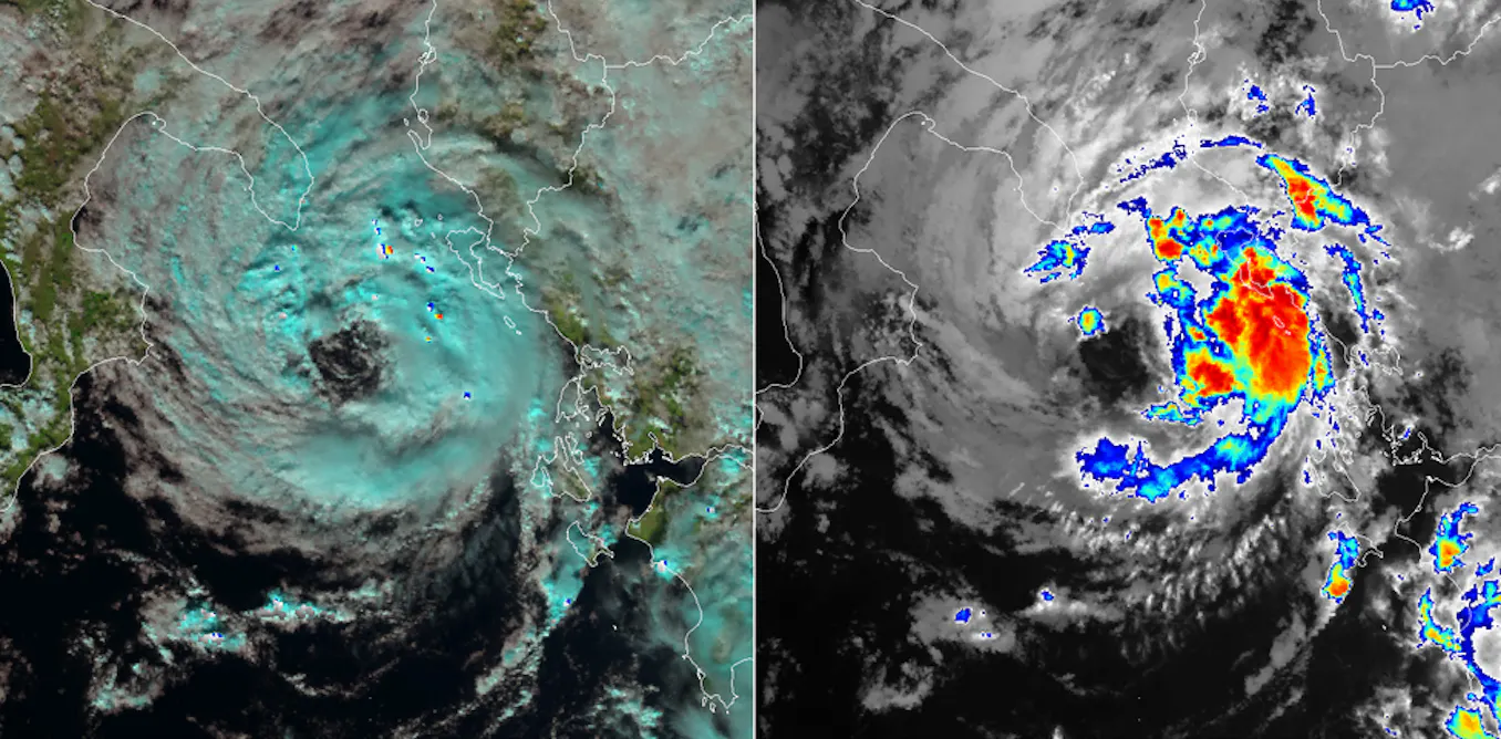
For several decades now, atmospheric depressions have been developing in the Mediterranean with characteristics that are reminiscent of tropical cyclones. These are known as medicanes, “Mediterranean mini-hurricanes”, or “Mediterranean tropical-like cyclones”.
These are low-pressure systems in the Mediterranean basin, with a warm core and a distinct, almost clear eye visible in satellite images, surrounded by dense, spiral-shaped cloud cover. They are accompanied by heavy rainfall and strong winds.

Records of medicanes date back beyond the 1960s, when global warming had not yet begun. It is true that the definitions of a medicane have varied and, in some cases, been rather broad, so the list of cases – which runs to around a hundred – should be reviewed. This means it is difficult to say whether they have become more frequent as water and air temperatures have risen.
By way of example, there were suggestions that Catalonia’s torrential rainstorms in early October 2026 were caused by a medicane. This was not the case. Neither the eye nor the spiral cloud structure was observed, the wind played no significant role, and a low-pressure did not form. However, there were several convective cells and mesoscale convective systems, which behaved in highly unusual – perhaps unprecedented – ways.
These storms need to be studied in detail, to assess whether they form part of the Mediterranean’s tropicalisation.
Read more: Tsunami risk in the Mediterranean: why Nice should prepare an evacuation plan
Increasingly erratic rainfall
Along the Mediterranean coast of Spain and other southern European countries, torrential rainfall can be caused by a variety of atmospheric conditions. These range from “cold drop” rains and persistent easterly winds, which drive moisture from the Mediterranean towards the coastal areas, to processes of cyclogenesis over the sea, mesoscale convective systems, and others. Th
Read More