

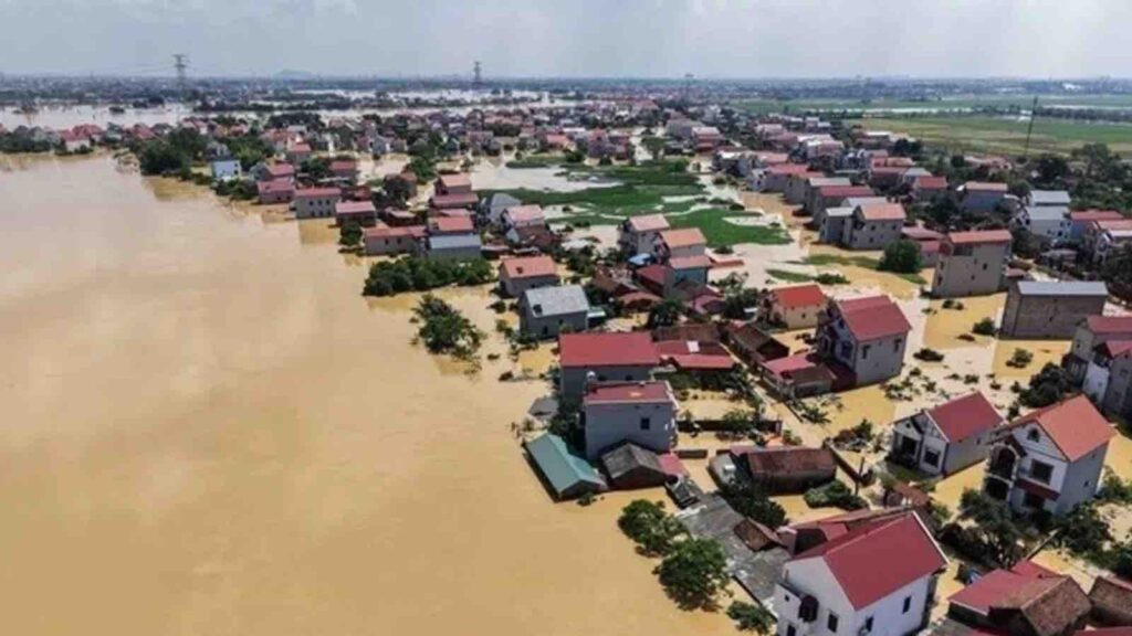
A report from the city’s Department of Agriculture and Environment on the morning of Oct. 10 said rising waters from the Cau and Ca Lo rivers inundated riverside communes including Kim Anh, Noi Bai, Soc Son, Tien Thang, and Trung Gia.
HANOI — Severe flooding has prompted authorities to evacuate nearly 8,500 residents on the outskirts of Vietnam’s capital, with more than 10,500 people already affected and plans underway to move around 38,500 others, largely in Trung Gia, Thu Lam, Tien Theng, and Da Phuc communes.
RELEVANT SUSTAINABLE GOALS
A report from the city’s Department of Agriculture and Environment on the morning of Oct. 10 said rising waters from the Cau and Ca Lo rivers inundated riverside communes including Kim Anh, Noi Bai, Soc Son, Tien Thang, and Trung Gia.
Evacuation Priorities and At-Risk Communities
The city’s Civil Defence Command said 5,866 residents in Trung Gia Commune—from the hamlets of An Lac, Do Tan, Lai Son, Do, and Trung Kien—remain at risk and need relocation. In Da Phuc Commune, about 30,000 peopleacross 33 hamlets are also in danger and may need to move to safer areas.
Authorities plan to prioritize local, on-site evacuation where possible, using multi-storey buildings for shelter, while others will be temporarily relocated to military and police barracks in nearby communes.
Dykes Overtopped as Floodwaters Surge
Floodwaters from the Cau and Ca Lo rivers overtopped the embankment along a 7.5 km stretch, reaching 0.02 to 0.2 m above the crest. Local authorities in Da Phuc moved to reinforce the dyke system to protect lives and property.
While water levels in major rivers running through Hanoi—the Da, Hong (Red), and Duong—remain below Alarm Level 1, they are still high. The Cau River has exceeded Alarm Level 3 by 2.06 m and stands 0.66 m above its designed flood level; the Ca Lo River is 1.56 m above Alarm Level 3 and 0.06 m above its design flood level of 9.5 m. Water levels in most irrigation reservoirs—Suoi Hai, Dong Quan, Tan Xa, Xuan Khanh, Quan Son, Van Son, and Keo Ca—also remain high.
As of 7 a.m. local time on Oct. 10, Da Phuc Commune reported 978 ha of rice and crops submerged, including 547 hain inland fields and 431 ha outside riverbanks. Authorities have urged farmers to harvest late-season rice as quickly as possible; as of Oct. 10, about 500 ha remain unharvested.
Damage to Irrigation and Transport Infrastructure
Irrigation systems have sustained multiple incidents, including a 15 m embankment slide at the Tang Long pumping station, a 30 m slide along the Ben Tre drainage canal, and more than 250 m of irrigation channels damaged or tilted. Six local road sections are reported partially flooded.
On the Ta Ca Lo dyke, three landslide spots have appeared, with sections at K17+700 and K8+270 each collapsing over 30 m. In Trung Gia Commune, severe erosion and washouts caused water to breach the Ha Thai railway embankment along a 20 m stretch near Thong Nhat, Trung Kien, and Do hamlets. Eighteen hamlets, home to 4,041 households, have been isolated.
Authorities are moving to stabilize embankments, maintain shelters in multi-storey buildings, and stage evacuations to nearby military and police barracks as needed. With river and reservoir levels remaining high, the city continues monitoring and reinforcement to safeguard residents, protect agricultural assets, and restore key irrigation and transport links as conditions allow.
Source: Vietnam News/Asia News Network.
You may also be interested in :
WMO Warns: Only One-Third Of River Basins Were ‘Normal” in 2024 As Drought and Floods Surged