

High-resolution satellite mapping will track changes to coral reefs, seagrass meadows and mangroves as scientists and marine groups weigh the ecological, recreational and cultural implications of possible reclamation around Singapore’s southern islands.
SINGAPORE — Singapore is preparing a new high-resolution map of its coral reefs, seagrass meadows and mangroves, creating an updated picture of coastal habitats as the Government considers merging several southern islands through reclamation to form a new western island.
The National Parks Board, or NParks, published a tender for the mapping exercise on Aug. 25. Using high-resolution satellite imagery, the study will update maps produced in 2018 and 2011 and measure how the habitats have changed.
Karenne Tun, group director of NParks’ National Biodiversity Centre, said the work is part of the board’s regular study of Singapore’s coastal and marine habitats. The resulting geospatial dataset will be made publicly available.
The project is expected to take 15 months and will exclude marine waters around Pedra Branca.Its timing has drawn particular attention because Prime Minister Lawrence Wong announced at the National Day Rally on Aug. 23 that Singapore could create a larger western island by merging several outlying islands. Pulau Semakau, Pulau Bukom and Pulau Sudong are among those that could be affected, along with smaller islands.
The new land is envisioned to meet Singapore’s industry, energy and defence needs in the decades ahead.
RELEVANT SUSTAINABLE GOALS
Much of Singapore’s Remaining Coral Habitat Lies in the South
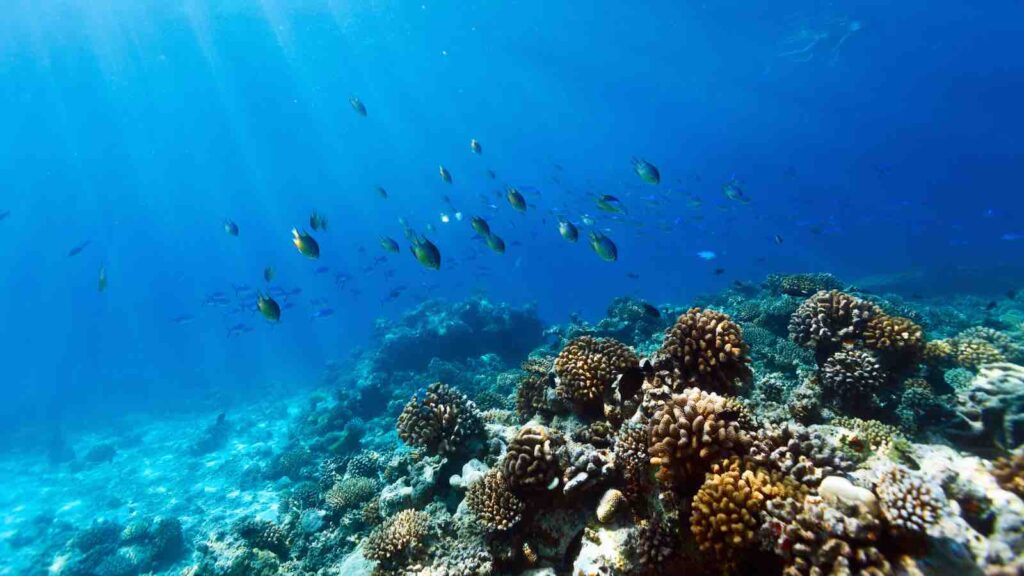
The waters surrounding Singapore’s southern islands contain most of the country’s remaining coral reef ecosystems, along with seagrass meadows and mangroves.
Huang Danwei, director of the National University of Singapore’s National Institute for Marine and Ocean Sciences, said the area being considered for reclamation contains substantial stretches of all three habitats, representing significant proportions of their total area in Singapore.
Some have been there for thousands of years.
Coral reefs around Pulau Hantu and Pulau Semakau date back about 8,000 years, Huang said. They were already growing long before modern Singapore was founded and provided ecological services when the area was a known fishing village.
Those functions include supplying food and helping prevent coastal erosion.
Their location also makes them a transition habitat between reefs across Southeast Asia. Larvae from various species stop in these ecosystems, supporting biodiversity and fisheries at a regional scale.
Huang described the reefs as among the most extensively studied in the world because they have persisted through years of coastal development and reclamation.
New Maps Could Shape Future Reclamation
Scientists say updated information about the precise boundaries and areas of marine habitats could help Singapore plan development while limiting ecological damage.
The coastline has likely changed considerably as it has been exposed to sea-level rise, climate-driven storm surges and marine heatwaves.
Huang said accurate maps could provide a reference for measuring environmental changes after construction and allow planners to reshape reclamation profiles to avoid productive coral reefs, dense seagrass beds and mangrove forests that store significant amounts of carbon dioxide.
The information could also improve predictions about biodiversity by showing more precisely where ecosystem-forming species are likely to occur as environmental conditions change.
“Such projections are important not just for ecosystem management, but also are helpful for long-term planning of navigational routes and the sea space in general,” he said.
Tun said the updated map would support conservation and sea-space planning across Singapore while complementing research by other agencies.
Scientists See a Chance for Evidence-Based Conservation
Sam Shu Qin, a coral scientist and co-chair of the voluntary network Friends of Marine Park, said the mapping could help identify conservation areas and places where intervention should be prioritised.
The public dataset could also be used by researchers, educators and nature groups to support research and explain the importance of the country’s remaining coastal habitats and wildlife.
Marine biologist Ow Yanxiang, who co-led Singapore’s first seagrass restoration project, said the data would make it possible to track cumulative changes to the coastal environment since 2018.
That broader view matters because environmental impact assessments for individual developments in these areas are often conducted independently.
“Our coral reefs, seagrass beds and mangrove forests have survived our nation’s many years of growth and development, so can we engineer ways to build our future with nature, instead of over it?” said Ow, a senior research fellow at the St John’s Island National Marine Laboratory.
Reclamation Could Permanently Remove Ancient Reefs
For reefs that fall directly beneath reclaimed land, Huang said the loss would be irreversible.
Land reclamation can remove ecosystem functions such as climate mitigation and ecological connectivity, although conserving pockets of existing habitat could reduce some of the damage.
Huang said transplanted corals would not replicate the functions and services of established reef systems, and rebuilding reefs of comparable age would require another 8,000 years of suitable environmental conditions.
The loss could also affect future research and remove potential ecosystem benefits, including sources of new medicines and materials.
He suggested protecting pockets of natural reef habitat from reclamation and moving coral fragments to adjacent reefs where possible.
Marine Groups Ask Singapore to Consider Heritage Alongside Nature
Ng Lee Kiang, co-founder of nature education company Young Nautilus, raised another concern: sediment plumes from future reclamation could spread beyond the immediate construction area.
She said they could affect Pulau Hantu and Pulau Semakau as well as nearby Sisters’ Islands Marine Park and St John’s Island, where Young Nautilus regularly conducts programmes.
“As educators, our deepest hope is that generations to come will still have the chance to experience, appreciate and learn about the rich marine biodiversity we are fortunate to have today,” Ng said.
Orang Laut SG, a non-governmental organisation that began as an initiative to preserve the maritime heritage of islanders from Pulau Semakau, has called for social and cultural effects to be considered alongside environmental ones.
The group, whose work concerns a subset of Singapore’s seafaring native communities, is also seeking continued access to surviving islands, coral reefs and coastal waters. “Environmental assessments alone cannot account for the loss of heritage, community access, livelihoods, traditional knowledge and relationships with the sea,” it said.
You may also be interested in :
Major Blind Spot in Ocean Carbon Research Could Undermine Global Climate Predictions
