



New research shows long-term land sinking after powerful earthquakes may lead to underestimated sea-level projections across the region.
SINGAPORE — Major earthquakes in Southeast Asia may continue to reshape the region long after the ground stops shaking, with new research showing that decades of post-earthquake land sinking could significantly affect sea-level projections and increase coastal flood risks if not properly accounted for.
The international study, led by earth scientists from Nanyang Technological University, Singapore (NTU Singapore), found that large earthquakes can trigger slow geological processes deep beneath the Earth’s surface, causing land across Southeast Asia to continue sinking for years or even decades.
The findings, published in Communications Earth & Environment, a Nature Portfolio journal, suggest that existing sea-level models may underestimate future flood risks for low-lying coastal communities because they often focus primarily on climate-driven factors such as melting ice sheets and ocean warming.
RELEVANT SUSTAINABLE GOALS



Weak Mantle Layer Beneath Sumatra Continues to Shift After Major Earthquakes
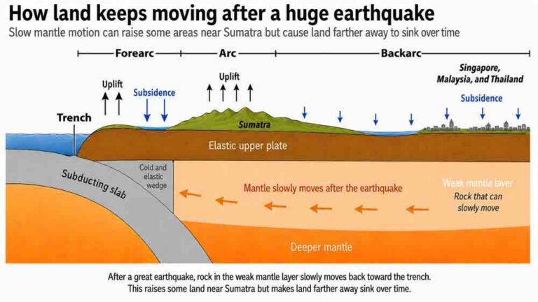
The research found that a weak layer of hot rock in the upper mantle beneath the Sumatran backarc—the region located behind Sumatra’s volcanic mountain chain—continues to deform after major earthquakes.
Although this mantle layer remains solid, it is capable of flowing slowly over time. As it moves, the land above continues to shift and gradually sink long after the initial earthquake has ended.
The study was led by NTU’s Earth Observatory of Singapore (EOS) Research Fellow Dr. Grace Ng, Assistant Professor Lujia Feng from NTU’s Asian School of the Environment (ASE), and Professor Emma Hill, Chair of ASE and Interim Director of EOS.

Land Subsidence Can Accelerate Relative Sea-Level Rise
While global sea-level rise is primarily driven by climate change through melting glaciers, ice sheets and warming oceans, the study emphasizes that relative sea level depends on both ocean levels and local land movement.
When land sinks, relative sea levels rise faster than ocean levels alone would suggest.
The researchers found that major earthquakes initiate long-term land subsidence across Southeast Asia, creating an additional factor that can increase flood risks in coastal areas.
Because scientists have only developed a better understanding of these long-term geological movements over the past decade, the study suggests they may not yet be fully incorporated into current sea-level projections.
As a result, future coastal flood risks for low-lying regions could be underestimated.
The researchers also noted that similar geological processes may occur in other subduction zones around the world where one tectonic plate moves beneath another.
Decades of Ground Movement Recorded Across Southeast Asia
To understand how the Earth’s surface responds after major earthquakes, the research team analyzed up to two decades of ground movement data collected from GPS stations across Singapore, Malaysia and Thailand.
The study examined movements following two major seismic events: the 2004 Sumatra-Andaman earthquake and the 2012 Wharton Basin earthquakes.
The data revealed that the ground continued moving even in locations situated more than 600 kilometres away from the earthquake epicentres.
According to the researchers, such widespread and prolonged movement indicates that a weak mantle layer beneath the Sumatran backarc allows the Earth’s surface to continue adjusting long after the earthquakes themselves.
Lead author Dr. Grace Ng said massive earthquakes trigger more than just short-term ground shaking.
“When massive earthquakes strike, they do not just shake the ground for a few minutes. They set off a slow adjustment deep within the Earth that can continue for years,” she said.
“Our study shows that a weak layer of hot rock beneath the Sumatran backarc can slowly deform after major earthquakes. This helps explain why the land above can continue to shift and sink across areas hundreds of kilometres away from the earthquake.”
Computer Models Confirm the Source of Long-Term Land Movement
To investigate the geological processes beneath the surface, the researchers developed computer models of the Earth’s interior and compared them with GPS measurements collected across the region.
The team found that the recorded land movement could only be explained if the upper mantle beneath the Sumatran backarc was sufficiently weak to flow gradually over extended periods.
The findings provide scientists with new insight into how major earthquakes continue influencing land elevation years after seismic activity has ended.
Assistant Professor Lujia Feng said the research depended on more than a decade of continuous regional observations.
“This study would not have been possible without more than a decade of continuous observations from ground-based GPS networks across the region,” Feng said.
“Such long-term geodetic records are vital for revealing how the solid Earth responds to great earthquakes, and how these processes evolve over time.”
Study Calls for Improved Coastal Planning Across Southeast Asia
The researchers say future sea-level projections for Southeast Asia should incorporate both climate-driven ocean rise and earthquake-induced land movement.
For coastal planners, relative sea level—the height of the sea compared with the land at a specific location—is the most important measurement.
If land continues sinking, water levels rise more rapidly relative to coastlines, increasing flood risks for vulnerable communities.
Senior author Professor Emma Hill said understanding geological movement is becoming increasingly important for improving future projections.
“Most current sea-level projections focus primarily on climate factors like ice-sheet melting and ocean warming, but we must also look at how the Earth moves beneath our feet,” she said.
“Our new study shows that post-earthquake land sinking is an important factor in regional relative sea-level change. Incorporating these deep geological movements into our models will help us improve coastal planning for low-lying cities.”
Better Models Could Strengthen Long-Term Climate Adaptation
The study concludes that integrating post-earthquake land movement into regional sea-level assessments could improve coastal risk modelling throughout Southeast Asia.
By accounting for both rising seas and sinking land, future planning for flood defences, drainage systems and coastal infrastructure can be supported with more comprehensive projections of long-term flood risk.
As Southeast Asia continues to experience both climate-driven sea-level rise and significant tectonic activity, the research highlights the importance of considering the interaction between geological processes and climate change when planning for the region’s coastal future.
