

Google's latest annual environmental report published July 24 highlights how it is creating a formidable portfolio of climate action tools that use AI for everything from predicting floods and wildfires to calculating emissions associated with transportation routes to detecting changes in biodiversity.
"We’re applying AI to problems that can help people live more sustainably and adapt to climate change … AI is a powerful tool for optimization, and we are using it to optimize our own operations, and we’re working to reduce energy use and emissions from AI computing in our data centers," wrote the company’s top sustainability executives Ben Gomes, senior vice president of learning and sustainability, and Kate Brandt, chief sustainability officer, in a blog post about the report.
In its report, however, the company also noted: "We must also continue to find ways to reduce the environmental footprint of AI models."
For at least a half-dozen years, Google has credited artificial intelligence with enabling some of its toughest sustainability achievements, particularly in decreasing how it uses energy across its vast network of data centers and switching to more renewable electricity resources.
Jeff Dean, chief scientist for Google DeepMind and Google Research, notes that the workloads of AI are growing fast — but it can also be part of the solution. Google researchers have already reduced the energy required to train an AI model by up to 100 times and the emissions by up to 1,000 times, he wrote in the report. "We plan to continue applying these test practices and to keep developing new ways to make AI computing more efficient."
The report doesn’t explore the topic much further, but Google has reason to be concerned — and it isn’t just electricity that’s a problem. Google’s water consumption is rising dramatically in lockstep with the company’s addition of more data centers to support its AI technologies. Water is important for keeping data centers cool, and in 2022, Google consumed 5.6 billion gallons globally, compared with 3.4 billion gallons in 2019.
Google committed in September 2021 to replenish 120 percent of the freshwater it consumes in data centers and offices by 2030. As of 2022, though, it has managed to replenish only 6 percent of its consumption, or 271 million gallons of water. One challenge is a dearth of water replenishment projects, the company reported.

![]()
![]()
![]()
![]()
![]()
![]()
![]()
![]()
On a more positive note, Google is dedicating an appreciable amount of its growing AI capacity to services addressing many dimensions of the climate crisis, including:
1. Automating reductions in energy consumption
Are you using a Nest thermostat? These gadgets use machine learning to adjust settings based on data such as weather predictions, occupancy schedules and grid power mixes. The Nest Renew service, for example, lets homeowners prioritize using clean energy when possible. Google reports that Nest thermostats have supported cumulative reductions of 113 billion kilowatt-hours of energy since 2011, double the annual power consumption of Portugal.
2. Decommissioning unused computers and IT equipment
One service offered to Google Cloud customers is Active Assist, which uses machine learning algorithms to identify workloads within a company’s information technology infrastructure that may be "zombies," using energy unnecessarily. The feature helps users turn off those resources, potentially cutting carbon emissions.
Active Assist is part of the Carbon Sense Suite, which also includes a resource that helps companies calculate monthly emissions data related to their technology.
3. Identifying water security risks
Google has created multiple resources that provide climate-related information about ecosystems. Many of these tools pull data from Google Earth Engine, introduced in 2010 and now hosting 1,000 climate- and nature-related observation data sets. (If you’ve watched glacial retreat videos, chances are Google Earth is behind them.)

![]()
![]()
![]()
![]()
![]()
![]()
![]()
![]()
The Freshwater Ecosystems Explorer, developed in partnership with the United Nations Environment Programme and the European Commission Joint Research Center, should be of interest to sustainability teams actively developing water stewardship strategies. Among other things, it visualizes estimates of how water is being transferred from land into the atmosphere.
4. Mapping urban tree canopies in a quest for more shade
Part of the free Environmental Insights Explorer, intended for civic and regional planners, is a module called Tree Canopy Insights. The tool uses a combination of machine learning and aerial photography to assess tree coverage in certain neighborhoods and model reforestation scenarios that could reduce urban heat islands. As of March, it covers 350 cities on four continents.
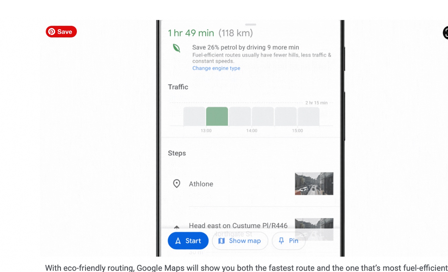
5. Planning better routes from Point A to Point B
You probably already know that Google Maps provides an eco-friendly routing option for drivers. Aside from calculating the time a certain way will take, it tells you which option uses the least amount of fuel or battery power, using resources such as the Environmental Protection Agency’s Greenhouse Gas Equivalencies Calculator. Drivers can opt into this feature by updating their mobile phone settings to include information such as the sort of engine in the vehicle they’re using, along with how many wheels propel it.
![]()
![]()
![]()
![]()
![]()
![]()
![]()
![]()
Google is also piloting a project that’s part of Environmental Insights Explorer called Green Light, which is used to measure data at busy intersections and make AI recommendations to optimize the changing of traffic lights with a view to decreasing emissions. Early results have shown a reduction of about 10 percent, according to Google’s environmental progress report.
6. Predicting floods and mapping wildfires
Google began using AI for flood predictions in India and then Bangladesh. As of May, its Flood Hub platform — which can provide forecasts up to seven days in advance — covers areas of high flood risk in 80 countries across Africa, Asia-Pacific, Europe, and South and Central America. Just one year ago, the predictions were available only two days in advance.
When it comes to wildfires, Google has adapted its Search and Maps services using satellite imagery and AI analysis from Google Earth Engine to provide data about active hot spots. The mission is to identify and illustrate wildfire boundaries, to provide valuable insights for firefighters and to keep local citizens safe.
Walking the AI talk
The above examples represent some of the higher profile tools detailed in Google’s 104-page environmental update, which offers metrics related to progress in 2022. Google also uses AI to manage elements of its own sustainability program.
For example, the company uses automated controls and m
Read More