

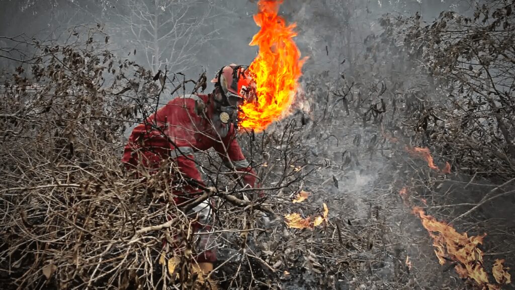

WALHI records 34,262 hotspots and 33,837 hectares burned before the dry season reaches its peak.
Forest and land fires are intensifying across Kalimantan, where several provinces have recorded sharp increases in hotspots and West Kalimantan has emerged as the most severely affected.
From January through July 2026, the Indonesian Forum for the Environment, known as WALHI, recorded 34,262 hotspots and 33,837 hectares of burned land across the island, making Kalimantan the epicentre of Indonesia’s forest and land fire crisis even before the dry season reached its peak.
Across Indonesia, 118,420 hotspots were recorded during the same period, with an indicative burned area of 107,649 hectares.
West Kalimantan reported the highest number in Borneo, with 17,236 hotspots and approximately 28,680 hectares affected by fire. Hotspots and fires were also recorded in Central Kalimantan, South Kalimantan, East Kalimantan and North Kalimantan.
WALHI said the figures point to a crisis shaped not only by weather but also by long-running failures in forest and land governance, corporate licensing, peatland protection, law enforcement and disaster preparedness.
RELEVANT SUSTAINABLE GOALS


Hotspots Rise Sharply in July
WALHI recorded a steep increase in hotspots during July 2026.
Between April and June, the monthly total never exceeded 74 hotspots. In July, the figure rose significantly to 615.
West Kalimantan also experienced a notable increase, recording 778 hotspots, or approximately 65 per cent of all high-level hotspots in Kalimantan.
Indra Syahnanda, head of advocacy and campaigns at WALHI West Kalimantan, said forest and land fires had been occurring in the province since January 2026.
He said the Meteorology, Climatology and Geophysics Agency, or BMKG, had predicted that West Kalimantan would continue to receive rainfall, yet hotspots continued to emerge.
“This means the forest and land fire disaster is not solely influenced by the weather,” he said.

Most Hotspots Found Inside Licensed Areas
One of WALHI’s central findings is that most of Kalimantan’s hotspots were located within corporate concessions.
Of the 34,262 hotspots recorded across the island, 25,524, or approximately 74 per cent, were found in licensed areas.
“The details show that 10,739 hotspots were located in oil palm plantation concessions, 7,880 in mining concessions and 6,905 in forest utilisation business permit areas,” Uli Arta Siagian, WALHI’s national campaign coordinator, said in late July.
WALHI argues that the forest and land fire crisis cannot be separated from the management of business permits and weak enforcement against companies. It also says the state has failed to ensure the protection of important ecosystems, including peatlands and forests.
Years of Peatland Development Increase Fire Risk
According to Indra, the most fundamental cause is poor forest and land governance that has continued for years.
Since the mid-2000s, numerous business permits have been issued in West Kalimantan’s peat hydrological units. This encouraged corporations to clear land, including through burning, and to build canals that dried the peat, making the areas increasingly vulnerable to fire.
His records show that 2.79 hectares of peat hydrological units in West Kalimantan are burdened by 135 oil palm plantation permits, 123 mining permits and 35 forest utilisation business permits.
“Today, indications of the damage can be seen in the distribution of hotspots,” Indra said. “Of the 17,236 hotspots monitored from January through July 2026, around 7,000 were located in peat hydrological unit areas.”
The fires have worsened air quality across West Kalimantan.
Indra said smoke had covered 14 districts and cities, with the most serious conditions reported in Ketapang, Kubu Raya, Mempawah and Sanggau.
The conditions have contributed to an increase in acute respiratory infections. In February 2026, a resident of Galang Village in Mempawah Regency died, with the smoke suspected of having aggravated an underlying illness.
Central Kalimantan Faces Severe Heat and Peat Fires
Central Kalimantan is also experiencing serious conditions.
Janang Firman Palanungkai, executive director of WALHI Central Kalimantan, described the recurring disaster as being like a broken record playing again.
The provincial government has issued Governor’s Decree No. 142/2026, declaring an emergency preparedness status for forest and land fires.
“The situation in Central Kalimantan is so concerning that I feel Jakarta’s air quality, which has long been considered poor, is actually somewhat better,” Janang said.
“In addition to the smoke, Central Kalimantan is extraordinarily hot today. Temperatures can reach 45 degrees Celsius,” he added.
The worst conditions have been recorded in Palangkaraya, Pulang Pisau, Kapuas, East Kotawaringin and West Kotawaringin. Most of the fires have occurred in peat ecosystems.
“Even areas that were previously restored by the Peatland Restoration Agency are now burning extensively because of massive drainage caused by project activities,” Janang said.

Around 60 Percent of Central Kalimantan Is Burdened by Permits
Janang said the conditions could not be separated from worsening land governance in Central Kalimantan.
Of the province’s approximately 15.3 million hectares, around 60 per cent is burdened by various permits, many of them covering peat ecosystems.
“Central Kalimantan has around 2.55 million hectares of peat ecosystems, but many business permits have already been issued over them,” he said.
He said national strategic projects had further increased the vulnerability of peatland areas. One example is the people’s rice-field development project, which continues the food-estate model and operates extensively on peatlands.
“The people’s rice-field areas may not burn directly,” he said. “But when the land is filled, the surrounding peat areas dry out. Those surrounding areas then become highly vulnerable to fire.”
Janang said the situation demonstrated that the state had not learned from earlier failures in peatland management.
He compared the pattern with the one-million-hectare peatland project begun by President Soeharto in 1997.
At the same time, he said the state had often directed blame toward traditional farmers as the cause of forest and land fires, even though community farming activities had declined while fires continued to recur.
“In 2023, almost no residents were farming anymore, but fires still occurred,” he said. “That means the main problem is not traditional farming, but land governance that has already been destroyed.”
South Kalimantan Sees a Cycle of Floods and Fires
Raden Rafiq, executive director of WALHI South Kalimantan, said similar conditions were occurring in his province.
“When the rainy season comes, there are floods. When the dry season arrives, forest and land fires follow,” he said.
He said the cycle was the result of development and investment that had sacrificed the environment, particularly economic activity based on extractive industries and monoculture plantations.
According to Rafiq, many forest and land fires were deliberately triggered by companies seeking an easier way to clear land before planting new oil palm seedlings.
“We are therefore asking the government to conduct a comprehensive and transparent evaluation of permit holders responsible for forest and land fires,” he said. “Take firm action if they are proven negligent or deliberately allowed fires to occur, including by revoking their permits.”
He also called for an end to new permits in extractive industries and for improvements in the management and supervision of existing permits.
Disaster Preparedness Weakened by Budget Cuts
WALHI said government preparations remained weak as the fires intensified, a condition it linked to cuts in the disaster-management budget.
“The National Disaster Management Agency’s budget in 2026 is only around Rp3 trillion to Rp4 trillion,” Uli said. “That is far lower than the allocations during the forest and land fire crisis periods of 2015, 2019 and 2022 through 2024.”
The limited funding is not allocated solely to forest and land fires but must cover all types of disasters.
WALHI said the funding conditions had turned environmental protection regulations into “paper tigers” and increased the burden on communities already serving on the front lines of firefighting with limited facilities and financial support.
Warning of a Crisis Before the Dry-Season Peak
WALHI said conditions in Kalimantan had become a warning that the forest and land fire threat had entered an alarming phase and required an immediate response before the dry season reached its peak.
The organisation also cited the emergence of an “El Niño Godzilla.”
“If it is not anticipated, this year’s disaster could become worse than the forest and land fires of 2015 and 2019,” WALHI warned.
The organisation urged the government to correct the management of natural resources.
It called on President Prabowo to evaluate all business permits, particularly those covering peatlands and natural forests, revoke the permits of problematic companies and ensure that corporations finance ecosystem restoration and the response to forest and land fires.
“The government and the House of Representatives must also review regulations that conflict with the mandate of People’s Consultative Assembly Decree No. IX of 2001 on Agrarian Reform and Natural Resource Management,” WALHI said.
Government Records Show Fires Return Every Year
Government records also show that fires have occurred in Kalimantan every year.
Data from the Ministry of Forestry’s Forest and Land Fire Control Information System, or SiPongi, show that burned areas across Kalimantan’s five provinces have fluctuated during the past seven years. Major increases occurred in 2019 and again in 2023.
Central Kalimantan recorded the largest burned area in 2019, reaching 317,749 hectares.
Four years later, South Kalimantan recorded the largest area, at 190,394.58 hectares. Central Kalimantan followed with 165,894 hectares, while West Kalimantan recorded 111,848.43 hectares.
The burned area declined across all provinces in 2024 and 2025, but it never fell to zero
You may also be interested in :
30 Hotspots Detected in East Kalimantan, Call For Vigilance to Prevent Forest Fires