
Due to its thick, vast ice sheet, Antarctica appears to be a single, continuous landmass centered over the South Pole and spanning both hemispheres of the globe. The Western Hemisphere sector of the ice sheet is shaped like a hitchhiker’s thumb – an apt metaphor, because the West Antarctic ice sheet is on the go. Affected by Earth’s warming oceans and atmosphere, the ice sheet that sits atop West Antarctica is melting, flowing outward and diminishing in size, all at an astonishing pace.
Much of the discussion about the melting of massive ice sheets during a time of climate change addresses its effects on people. That makes sense: Millions will see their homes damaged or destroyed by rising sea levels and storm surges.
But what will happen to Antarctica itself as the ice sheets melt?
In layers of sediment accumulated on the sea floor over millions of years, researchers like us are finding evidence that when West Antarctica melted, there was a rapid uptick in onshore geological activity in the area. The evidence foretells what’s in store for the future.
A voyage of discovery
As far back as 30 million years ago, an ice sheet covered much of what we now call Antarctica. But during the Pliocene Epoch, which lasted from 5.3 million to 2.6 million years ago, the ice sheet on West Antarctica drastically retreated. Rather than a continuous ice sheet, all that remained were high ice caps and glaciers on or near mountaintops.
About 5 million years ago, conditions around Antarctica began to warm, and West Antarctic ice diminished. About 3 million years ago, all of Earth entered a warm climate phase, similar to what is happening today.
Glaciers are not stationary. These large masses of ice form on land and flow toward the sea, moving over bedrock and scraping off material from the landscape they cover, and carrying that debris along as the ice moves, almost like a conveyor belt. This process speeds up when the climate warms, as does calving into the sea, which forms icebergs. Debris-laden icebergs can then carry that continental rock material out to sea, dropping it to the sea floor as the icebergs melt.

In early 2019, we joined a major scientific trip – International Ocean Discovery Program Expedition 379 – to the Amundsen Sea, south of the Pacific Ocean. Our expedition aimed to recover material from the seabed to learn what had happened in West Antarctica during its melting period all that time ago.
Aboard the drillship JOIDES Resolution, workers lowered a drill nearly 13,000 feet (3,962 meters) to the sea floor and then drilled 2,605 feet (794 meters) into the ocean floor, directly offshore from the most vulnerable part of the West Antarctic ice sheet.
The drill brought up long tubes called “cores,” containing layers of sediments deposited between 6 million years ago and the present. Our research focused on sections of sediment from the time of the Pliocene Epoch, when Antarctica was not entirely ice-covered.

An unexpected finding
While onboard, one of us, Christine Siddoway, was surprised to discover an uncommon sandstone pebble in a disturbed section of the core. Sandstone fragments were rare in the core, so the pebble’s origin was of high interest. Tests showed that the pebble had come from mountains deep in the Antarctic interior, roughly 800 miles (1,300 kilometers) from the drill site.
For this to have happened, icebergs must have calved from glaciers flowing off interior mountains and then floated toward the Pacific Ocean. The pebble provided evidence that a deep-water ocean passage – rather than today’s thick ice sheet – existed across the interior of what is now Antarctica.
After the expedition, once the researchers returned to their home laboratories, this finding was confirmed by analyzing silt, mud, rock fragments, and microfossils that also came up in the sediment cores. The chemical and magnetic properties of the core material revealed a detailed timeline of the ice sheet’s retreats and advances over many years.

One key sign came from analyses led by Keiji Horikawa. He tried to match thin mud layers in the core with bedrock from the continent, to test the idea that icebergs had carried such materials very long distances. Each mud layer was deposited right after a deglaciation episode, when the ice sheet retreated, that created a bed of iceberg-carried pebbly clay. By measuring the amounts of various elements, including strontium, neodymium and lead, he was able to link specific thin layers of mud in the drill cores to chemical signatures in outcrops in the Ellsworth Mountains, 870 miles (1400 km) away.
Horikawa discovered not just one instance of this material but as many as five mud layers deposited between 4.7 million and 3.3 million years ago. That suggests the ice sheet melted and open ocean formed, then the ice sheet regrew, filling the interior, repeatedly, over short spans of thousands to tens of thousands of years.
Creating a fuller picture
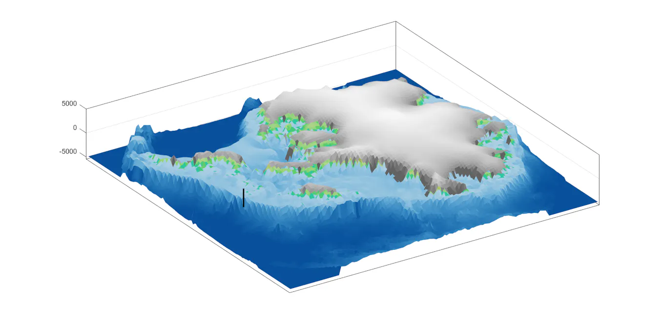
Teammate Ruthie Halberstadt combined this chemical evidence and timing in computer models showing how an archipelago of ice-capped, rugged islands emerged as ocean replaced the thick ice sheets that now fill Antarctica’s interior basins.
The biggest changes happened along the coast. The model simulations show a rapid increase in iceberg production and a dramatic retreat of the edge of the ice sheet toward the Ellsworth Mountains. The Amundsen Sea became choked with icebergs produced from all directions. Rocks and pebbles embedded in the glaciers floated out to sea within the icebergs and dropped to the seabed as the icebergs melted.
Long-standing geological evidence from Antarctica and elsewhere around the world shows that as ice melts and flows off the land, the land itself rises because the ice no longer presses it down. That shift can cause earthqu
Read More